Sunday, 25 February 2018

Carretera Austral


The Carretera Austral or ‘Southern Highway’ stretches for over 12,000 kilometres through the wettest, greenest, wildest region of southern Chile and is trailed as one of the world’s most scenic road trips. Our journey along this route began on Tuesday 13th February after leaving the border town of Chile Chico.

Chile Chico sits on the shore of Lago General Carrera, a huge and beautiful lake which it shares with Argentina (where it is known as Lago Buenos Aires) and in order to join the Carretera Austral it is necessary to drive 120 kilometres around a huge section of the lake. It was a good dirt road although quite narrow and vertiginous in places.  However, we had the most wonderful views of the aquamarine lake, the black snow-capped mountains and the verdant green of the forests and we both agreed that this was the most beautiful road we have ever driven.

On the road from Chile Chico around Lago General Carrera

View of Lago General Carrera and mountains beyond

Deep river gorge leading to the lake

Lunch stop by the lake

Local flora

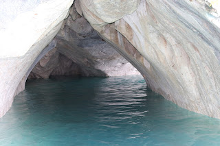
We camped for the night by the lakeside near the village of Puerto Rio Tranquillo and next morning got on a launch to the Capillas de Marmol (Marble Chapels).  These chapels have been formed due to erosion in a series of marble cliffs and islets which has created the most wonderful shapes in the rock. 

Capillas de Marmol

Capillas de Marmol

Capillas de Marmol

There were pinnacles, columns, peaks, peep-holes and caves into which we could take the boat and the colours were everything from the creamiest cream through to startling pink and green and brown.  The lake itself was of the most beautiful turquoise blue and when the sun shone, and mercifully it did for us, the reflection of the light from the water onto these marble swirls and decorated pillars, columns and ceilings was quite startling.

Capillas de Marmol

Capillas de Marmol

By Wednesday evening we had reached the small town of Cerro Castillo which sits at the bottom of the mountain from which it takes its name.  Unfortunately, we could not see the mountain because it was entirely shrouded in mist and cloud. Luckily the sun shone next morning and so we climbed up the hill and had a wonderful view of the mountain with its sharp castellated ridges and attendant cloud.

Cerro Castillo

Back on the road again we encountered tarmac for the first time since we set off from Chile Chico which was very welcome. We drove through forests and for much of the time following the course of a river.

We arrived in the small city of Coyhaique on Thursday where we stayed for a couple of days to stock up on provisions, do the usual admin and get an oil change for Footloose Lucy.

Whilst we were in Coyhaique we met an interesting guy by the name of Tim.  Originally from Hampshire, Tim has lived and worked in Coyhaique for the past fifteen years and gave us all sorts of useful information.  He also happens to be a part time guide at an estancia some 50 kilometres or so from Coyhaique where condors roost.

We duly arranged to go to the estancia with Tim to see the condors early on Tuesday 20th February.  Having achieved all that we needed to in Coyhaique we spent the intervening couple of days at a lovely cabana in the countryside a few kilometres from the city. It was situated in a semi meadow which was covered in wild flowers and with views across to the mountains and down to the small but pretty Rio Baguales below us.

The owner of the cabana told us that the Rio Baguales was full of small but very hungry trout and he was right.  We walked down and spent a morning there during which time Alan caught three fit and feisty trout, each weighing about three quarters of a pound.  He also cast a fly or two in the much larger Rio Simpson, said to be full of very large trout, but had zero success.

Rio Simpson

We left the cabana on Monday and then drove along dirt road to a dried up river bed which Tim had told us about which was close to the estancia.  There we set up camp for the night and, as it was very cold, we lit a campfire and we sat round it and had our supper and then chatted until about ten o’clock by the glow of the fire.

Bush camp near Estancia Punta del Monte

Keeping warm by the campfire

During this time a couple of vehicles went past, that was about it, but then just after ten o’clock the police arrived with their lights flashing and required us to put the fire out forthwith which we did with their assistance. We were about to go to bed by then, so the fire had pretty much died down anyway.

The bonus was that once the fire was out and the constabulary had departed, lights still flashing, we stood and looked at the sky, a wonderful clear sky, no ambient light whatsoever and a million stars!  Alan saw one shooting star, we saw the Milky Way as clear as it is probably possible to see it, a great white swathe of a million, million stars crossing the sky.  We saw Orion and we stood for about half an hour just gazing up in wonder.

Dawn at the bush camp

A little later

On Tuesday morning we were up early because we had been promised the condors. Tim arrived just after half past six and we set off.  We drove with Tim in his vehicle up through the southern beech woods out onto a high rocky precipitous cliff and there we waited.  The wind was fierce and it was very cold but the views all around us were magnificent.


Jagged mountain top, condor roost

Windswept mountain top vegetation, living and dead

We were not disappointed with the condors.  We saw in total eleven at one time and Alan got some reasonably good shots. We hugely enjoyed being on this desolate, cold windswept mountain top with the stunted trees and the recumbent plants and the mighty view over the glacial plain down to a series of lagoons. We also saw a black faced buzzard eagle and a number of smaller birds, but it was the condors with their eleven-foot wing span that stole the show.

Adult male condor

Adult female condor

Adult male condor

On the way back Tim took us to a field on the estancia which is archaeologically unique.  It’s a place where the indigenous Indians used to gather and work stone tools.  We found obsidian which apparently is not found closer than a thousand miles from that location along with other quartz like stones, all of which had been worked.  He also showed us another place that was full of fossils. Many of them were like tiny starfish and there were other worm like casts and these were all presumably from the sea bed when the area was a shallow tropical sea, hard as that was to imagine. 

Fossils of starfish like creatures

Armadillo seen on the estancia

Finally, Tim led us to a very pretty river and after a bit of struggling we got down to the banks.  The river was undoubtedly full of fish, they were jumping all over the place but none of them was the least bit interested in any of the fly that Alan cast.

Tuesday turned out to be a very long day so we had one final night at the cabana before setting off north again on the Carretera Austral on Wednesday morning.

It was not long before there was a large diversion in place on the Carretara Austral and we were sent along a winding back road through the mountainous countryside. At the bottom of every valley there was a beautiful river, many of them wide and some of them small, full of boulders and chuckling little cascades.  The sides of the valleys led up to the mountains and these mountains were covered in trees, many of them apparently growing from the vertical rock sides.  The course of the road, which was all dirt and quite narrow in places, wound continuously from left to right and up and down like a big dipper.  Inevitably we didn’t make quick progress but the drive was quite beautiful.

Typical view from the Carretera Austral

Just another waterfall

Viaduct on the Carretera Austral

After stopping for the night at a pretty little campsite in the village of Manihuales, we continued north on a paved section of the Carretera Austral and then stopped to camp the following night on the banks of a fjord close to Queulat National Park.

Campsite at evening, by the fjord near Queulat National Park

On Friday morning we packed up and went into the national park which is full of extensive evergreen forest but also a spectacular hanging glacier. The glacier protrudes from a high valley from the bottom of which issue a number of snow melt waterfalls which go down into a large glacial lake.

Hanging glacier with waterfall

Hanging glacier

Snowmelt river fed by hanging glacier

Glacial lake with glacier in the background

Sue on the hanging bridge

Having seen all we wanted to in the National Park we then travelled the short distance to the delightful little town of Puyuhuapi which sits at the head of the fjord.  It is a quiet, gentle place and we have spent a wonderful couple of days respite here. 

Sunset over Puyuhuapi fjord

Boat no longer seaworthy, Puyuhuapi

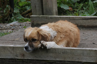
Bored puppy

Local cottage, Puyuhuapi

We spent several hours yesterday kayaking along a beautiful stretch of the fjord and when we stopped for our picnic lunch we were entertained by three dolphins who cavorted about 50 metres from us for about half an hour.

Kayaking on the fjord

Lunch stop on the fjord (dolphins just visible)

Tomorrow is Monday 25th February and our plan is to get back on the road and continue the short distance to La Junta where we will be leaving the Carretera Austral.  This is rather sooner than we had originally intended, the reason being that the road is closed after La Junta at the village of Villa Santa Lucia.  Just before last Christmas a huge landslide caused by the collapse of a glacial lake wiped out Santa Lucia along with 60 of its inhabitants and, of course, the road which has not yet been rebuilt.  We understand that we need to go to La Junta to book a ferry to circumnavigate the area and we are hoping that we can get on one to the island of Chiloe, but we shall see!

Monday, 12 February 2018

Walk on the Wild Side

On Wednesday 31st January we arrived in Puerto Natales, this being the town from which most people depart for the Parque Nacional Torres del Paine.  It’s quite a nice town and we spent a pleasant couple of days there catching up on the usual admin and domestic chores and visiting the nearby Cueva del Milodon.

The Milodon was a giant sloth about twelve feet high that lived in these parts up to about 14,000 years ago when it became extinct, but whether by the hand of man or climate change is uncertain. What is certain is that the remains of these things were found in this mighty cave that we visited.

The cave had been carved out by sea action millennia earlier, the width of it was about 150 metres and the depth about four or five hundred metres.  It was very impressive, and we much enjoyed our visit there.

Milodon's eye view of Chile

We also saw black neck swans for the first time whilst we were staying at Puerto Natales. There were dozens of them bobbing up and down on the windswept sound just outside the town, several of them with little cygnets also bobbing up and down in their wake. 


Black neck swan with cygnets

We left Puerto Natales on Friday and made our way to Torres del Paine national park. We had sight of the huge and very beautiful massif beyond the lakes long before we reached the park.  


On the road to Torres del Paine

Guanaco

The park itself was busy with visitors, many of them hiking the entire circuit which apparently takes about seven days.  Needless to say, we decided against that particular challenge, but we spent a wonderful couple of days camping in the park, walking at the base of the massif and climbing the Mirador Condor which gave us the most spectacular views.


Camping at the foot of Torres del Paine massif

Torres del Paine

The savage sharp toothed pinnacles of the Torres de Paine mountains rise precipitously from the plain and are very impressive.  The more sheltered southern slopes were still clad in show fields and these were melting to form rivulets of water and waterfalls cascading down the side of the mountain to gather together in big snowmelt rivers.


The Towers at Torres del Paine

Torres del Paine showing rock colour variation

From the top of the Mirador Condor we could see beneath us a series of lakes and lagoons, brilliant turquoise with the shadows of the clouds scudding across them, and a pattern of islands of various shapes and sizes distributed in the water. What we didn’t see was any condors, but then you can’t have everything.


Torres del Paine from across the lake

It was very windy and on the first night it felt a little bit like sleeping at the top of a poplar tree during a hurricane.  The tent was whacking around in the wind as though it was minded to go into orbit and we spent a little time wondering whether we would be looking at the stars ere long. We’re pleased to report that the tent behaved impeccably.


Armadillo patrolling our campsite

We left the park and the mountain behind us on Sunday 4th February, crossed back over the border from Chile into Argentina and headed north to the town of El Calafate.  The 250 kilometre drive itself across the flat Patagonian steppe, much of it on long straight dirt road, was exceedingly boring. There was the occasional herd of guanaco, and a few rheas, but mostly there was dust, dust which got in our eyes and in our ears and nose and inside the vehicle and generally was a nuisance.


Family of guanacos

El Calafate is situated on the south shore of Lago Argentino and is very close to the Parque Nacional los Glaciares.  This apparently is Argentina’s second largest national park, stretching about 170 kilometres along the Chilean border and with almost half of it covered by the Southern Ice Cap. El Calafate is a pleasant if somewhat touristy town.

There is a wetland area covering about three or four hundred acres on the edge of the lake which we decided to visit, Alan as always accompanied by his telephoto lens.  It was modestly trailed as the municipal reserve so we weren’t expecting very much.  However, we were wrong.


Cinereous Harrier, El Calafate Wetland

Male Upland Goose

Female Upland Geese

We both agreed that we have never seen so many diverse species of bird in such a small wetland habitat.  There were many species of duck and water fowl, Cinereous Harriers, long tailed larks, spectacled tyrant birds, black necked swans, Coscoroba swans and three flamingos standing on one leg looking as though they were pretending to be lollipops.  We spent several hours there and much enjoyed walking the trails in the very well managed reserve.


Black Faced Ibis

Female Yellow Billed Pintail Duck

Our main reason for staying at El Calafate was to visit the huge Glacier Perito Moreno, one of the few accessible glaciers in the world.  On Tuesday morning we duly drove 70 kilometres along the access road and then parted with the lower half of our wallets to gain admission into the national park.  It was worth it.

The glacier is between sixty and a hundred metres high, up to about five kilometres wide and thirty kilometres long.  Periodically, as we were looking at it there was a sound like a pistol shot which heralded the fall of a big lump of ice falling off and then splashing into the turquoise water below.

Glacier Perito Moreno

Sue at the Glacier

Bits of glacier waiting to calve

When seen from the top we thought the glacier looked a little bit like a frozen army. The surface of the ice has been eroded and melted into a series of crevasses, domes, and shapes, some of which appear to have eye holes and some mouth holes, and it appeared to us for all the world like a ghostly army that had been transfixed by some mighty wizard.  The sight of this huge expanse of ice was unforgettable.


Glacier showing perspective

View of the glacier from the road

On Wednesday we left El Calafate to continue north on the notorious Ruta 40, notorious for being one of the longest, wildest and least travelled roads in the world. Che Guevara apparently travelled along much of it on his famous motorcycle jaunts.

We covered 350 kilometres on the first day and it was mind bendingly boring for much of the way. The only thing that relieved the tedium was the patterns of the clouds that swayed and swirled above us.  We invented a game to try and find things that were of interest and that would help keep Alan awake whilst driving.  The game was called guanacos and trees with an additional bonus point for rheas.  The idea was that the first person to see one of these would get a point.  Now when we mention that after 350 kilometres we only saw about six trees and ten guanacos and one small flock of rheas you get the picture that it was not a scenic route.

Ruta 40 - miles and miles of f**** all

Shortly after our lunch stop we were flagged down by a young couple standing in the road in evident distress. They had a problem with their fuel pump or maybe their fuel filter but, either way, their little black car was not going anywhere.  For once on our travels we were able to offer help rather than seek it and we duly towed them for about 80 kilometres (30 kilometres of it on dirt road) into the little town of Gobernador Gregores.

This was followed by a slightly embarrassing episode for Alan which involved him being kissed by a perfect stranger who was hugely appreciative of what we had done.  That was all very well but Alan is a Yorkshireman and not used to being kissed by a bloke!

That said they were jolly nice people and ultimately they arrived at the same campsite that we were staying at. After a while, when we were sitting in front of our fire enjoying a slightly carbonised sausage, they turned up with some ceremony and gave us two large mugs inscribed with Ruta 40, an unnecessary but hugely appreciated gesture.

All in all, it was a memorable day, not just for the six trees, not just for the 350 kilometres of stuff all but also for the appreciation shown by two Argentinian strangers for our help in towing them for fifty miles.

We drove a similar distance on Thursday, but the landscape became slightly more interesting with more hills and more bends in the road.  We had been given the location of an interesting canyon by a fellow traveller which we found quite easily once we turned off Ruta 40.  The canyon known as Canacoles Chico turned out to be the most isolated but the most wonderful place to wild camp.

Wild camping in the Canacoles Chico Canyon

At the bottom of the canyon was a dried up salt lake which was probably a river bed.  The walls of the canyon were high, striated red and cream sandstone, carved and buffeted by the winds of centuries into strange shapes, caves, hollows, and turrets. Alan went to have a look in one of the caves and found it to be full of guanaco bones although we could only speculate on how they got there.

Sunset in the canyon

It was a most delightful wild and wonderful place, nobody for miles around and the rocks of the canyon face constantly changed from black to red to white as the clouds passed and the shafts of sunlight luminated the cracks, caves and crevasses which constituted the walls of the canyon.


A shovel comes in very handy when you're wild camping

On Friday morning we drove a short distance to a much larger canyon, the canyon of the Rio Pinturas where we visited the amazing Cueva de las Manos. This is one of the major cultural and archaeological sites in South America and was declared a World Heritage Site twenty years ago.


Rio Pinturas Canyon

Path to the Cueva de las Manos

The Cave of Hands has a series of galleries which contain hundreds and hundreds of pieces of cave art.  Many of these are stencils of human hands which apparently were executed by means of the person getting a mouthful of colour pigment and blowing it through a hollow bone around the outline of the hand.  There are scenes showing guanaco being hunted both with spears and with bola, there are mythical creatures and also a couple of representations of women giving birth which they appear to have done from the standing position.

Cueva de las Manos - appeal from the past

Guanaco hunt

Mythical monsters

The paintings which are in red, orange, black and white are quite beautiful in their own way and are remarkably well preserved. The oldest of the paintings are 9,000 years old and gave a fascinating insight into the lives of these hunter gatherer people over several millennia.

More than 800 hands, several thousand years

After the fascinating visit to the Cave of Hands we travelled the last couple of hundred kilometres to the border town of Los Antiguos.  There we managed to sort out a minor problem with the truck and caught up on the usual admin and domestic chores. Yesterday we crossed the border for the fourth time to the little town of Chile Chico.  Today is Monday 12th February and tomorrow we will continue our journey north on the Carretera Austral.